


When standing water mixes with wastewater, it can create serious public health and environmental concerns. This scenario is particularly dangerous in densely populated urban areas with inadequate wastewater infrastructure. Such contamination threatens to cause major public health crises in India’s Ganga region, where climate change-driven monsoonal flooding converges with the daily discharge of 6 billion liters of untreated sewage from over 600 million people.
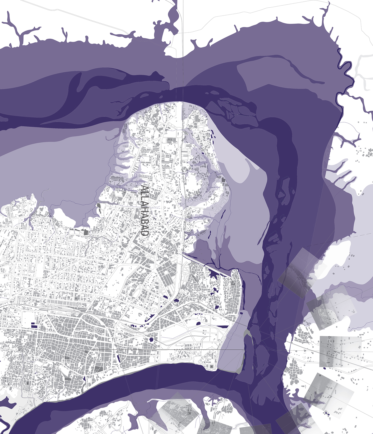
Most wastewater enters the Ganga River through small water courses known as naalas. These tributaries may function as irrigation stems, conduits, sewers, or drains, and when they feed into the Ganga, they deliver diverse pollutants. Naalas are critical hydrological infrastructures for farms and cities alike, yet they have been neglected as the origin of an expanding crisis in public health.
This lab looks at the ways in which naalas interface with urban growth, agriculture, and monsoons. Naalas are not only places where urbanization, local environmental degradation, and global environmental change intersect, resulting in acute health impacts for large local populations—they are also sites of great potential for green infrastructure to interrupt the harmful connection between climate and water-borne/enteric diseases. Our interdisciplinary team, led by Dr. Anthony Acciavatti, focuses on five interrelated workflows: monitoring, projecting, designing, evaluating, and maintaining.
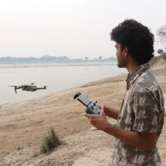
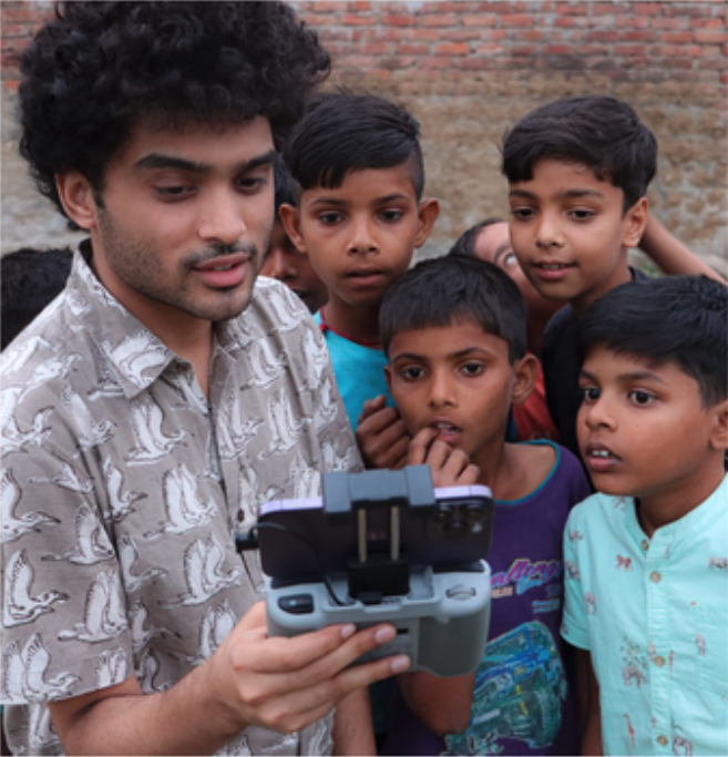
The Ganges team uses remote sensing, publicly available data, drone imagery gathered during field studies, and historical records to build an archive of the evolution of naalas. As part of this work, we have developed novel methods of measuring and mapping naalas and their adjoining land use and land cover. With their varying urban footprints and agricultural production, naalas have lessons to teach us that may be applied to other areas facing similar challenges. What are the common patterns of urban growth in the Ganges River watershed, and how do they relate to private property, municipal water supply, and land use? How do these correlated factors affect naalas and the kinds and quantities of pollutants they are delivering to the Ganges? Answering these questions are integral to a paper the lab is currently preparing for publication.
.png)
.png)
Building on the monitoring and mapping of naalas, we have developed vulnerability criteria to forecast which naalas will undergo significant changes in the next five and 25 years. Which areas along a naala will continue to be agricultural? Which areas may be transformed from farm to city? And where might agricultural production intensify and urban growth densify? The lab has submitted an article for publication that tackles these pressing questions. This work has helped us to identify naalas ripe for green infrastructure and landscape design.
In the Designing phase, we collaborate with local communities and the government of India to design and implement new forms of green infrastructure whose primary purpose will be filtration and treatment to reduce fecal coliform and total suspended solids, while increasing aeration and dissolved oxygen in and along naalas. We will create waterway environments that exemplify multi-use infrastructure: Redesigned naalas will not only improve water quality and security; they will also offer much-needed green public spaces for recreation and leisure. Moreover, in settings where electricity service tends to be unreliable, green infrastructure is more reliable in comparison to energy-intensive forms of water purification like sewage treatment plants. In this project, three distinct forms of in-situ green infrastructure will be used to deliver the benefits of improving water, sanitation, and hygiene: constructed wetlands, bioswales, and green piers.
In conjunction with the design of new green infrastructures, we will train a team of community field scientists to collect water samples, which will be analyzed using targeted metagenomic analysis techniques. The training program will be conducted in partnership with three local community institutions with deep roots in the area we will work in. Evaluating the effectiveness of the design of new green infrastructures is vital in order to achieve the best outcomes for each site, and to secure continued investment from the local community and beyond.
Along with training community field scientists to collect water samples, we will also partner with government and civic organizations to maintain the green infrastructures. Maintaining the new systems of pollution abatement as well as new parks along the edges of the naalas are essential to ensuring their continued effectiveness.
To date, Ganges Lab has been focused on all five workflows, with most of our attention on the first three. We are looking forward to moving closer to implementing designs along naalas and incorporating processes of evaluation and maintenance.
-
Architecture, History of Science, Yale University
Lab Leader
Architecture, History of Science, Yale University
Dr. Anthony Acciavatti is the Diana Balmori Assistant Professor at Yale School of Architecture, with a secondary appointment in the School of the Environment. He wrote Ganges Water Machine: Designing New India’s Ancient River, a comprehensive mapping and environmental history of the Ganges River Basin. Anthony spent years crisscrossing the basin, and designed new instruments to map soils and document the choreography of temporary cities and the periodicity of monsoons. He holds a PhD in the History of Science from Princeton.

Collaborative Earth
Lab Member
Collaborative Earth
Aaron Hirsh is a scientist, writer, and entrepreneur with deep interests in environmental education and ecological regeneration. Aaron’s research has appeared in a variety of journals, including Nature, Science, and PNAS, while his writings have been published by The New York Times, The Wall Street Journal, The Best American series, and FSG. As an entrepreneur, Aaron has been involved in bio- and ed-tech. He was also a founder of The Vermilion Sea Institute and Board Chair for Ecology Project International. He holds a BA from Princeton and a PhD from Stanford.

Environmental Science, Data Analysis, Freelance Professional
Lab Member
Environmental Science, Data Analysis, Freelance Professional
Ariel Chamberlain is an Environmental Scientist and Data Analyst passionate about supporting the revitalization of nature and environmental justice. Ariel is committed to leveraging their expertise with geospatial data, scientific research, and systems thinking to help design and implement solutions to our polycrisis. Ariel also advocates for life-long education and inclusive community building.

Computer Science and Environmental Design, MIT
Lab Member
Computer Science and Environmental Design, MIT
Claire Gorman Hanly studies the designed integration of sensing technologies with built and natural environments; including recent research into deep learning methods for glacial extent mapping, remote-sensing based classification of arctic wetlands and industrial croplands, and the implications of LLMs for the advancement of soil carbon modeling. Claire’s work holds a strong central theme of creative computer vision approaches applied to climate-oriented problems.
Aquatic Ecology
Lab Member
Aquatic Ecology
James Smoot is an aquatic ecologist with a doctorate in microbiology. He has 25 peer reviewed publications covering a broad range of microbiological and environmental studies such as periphyton-based water quality monitoring, detritivore mediated carbon transport, and water quality sensor design for the International Space Station.

Architecture, Landscape Architecture, Yale
Lab Member
Architecture, Landscape Architecture, Yale
Trained as both an architect and a landscape architect, Jingyi Wang is currently pursuing her Master of Architecture at Yale and holds a Bachelor of Science in Landscape Architecture from Cornell University, where she graduated with a concentration in socio-cultural landscape studies. Her research and design practice investigates how spatial analysis, ecological modeling, and field-based inquiry can inform interventions in sites of environmental degradation and the spatial inequality it produces.
Geospatial and Landscape Visualization
Lab Member
Geospatial and Landscape Visualization
Markley Boyer began his career in the digital side of the fashion photography business. He now works on conservation visualization projects. He recently created images of Manhattan island in 1609 as it appeared to the first European settlers.

AI and Data Science, Conquio
Lab Member
AI and Data Science, Conquio
Michael Warner has a Master’s degree in Artificial Intelligence and Business Analytics, specializing in Data Science with a focus on sustainability. He is excited about the prospect of doing real-world good by merging his two passions, data and sustainability, together and trying to create the world a healthier environment for all.

Architecture, Yale
Lab Member
Architecture, Yale
Nicole Cao is a Master of Architecture student interested in how built interventions can shape new ways to interact with a changing planet. She completed her undergraduate studies at the University of Waterloo, working in architecture offices and research labs in North America and Europe exploring new potentials for climate resilience, the emotional experience of space, and urban food systems.

Remote Sensing, University of Florida
Lab Member
Remote Sensing, University of Florida
Nikhil Raj Deep is a researcher who is focused on the use of multiple satellite sensors (Multispectral, Hyperspectral, and Microwave Remote Sensing) and spectroscopy towards developing models for hydrology and vegetation studies. He has worked on ISRO, DST, and DRDO projects that have utilized multi-platform remote sensing data toward terrain, environmental, and natural resource management issues, and he is skilled in ArcGIS Products, QGIS, Google Earth Engine, MATLAB, and R.
Labs Development Lead, CFW Lead, Collaborative Earth
Lab Member
Labs Development Lead, CFW Lead, Collaborative Earth
Sarah Bergmann works at the intersections of ecology, culture, environmental philosophy, and design. She was the designer and leader of the Pollinator Pathway, a civic project that brought together thousands of participants around a park designed to prioritize density within urban environments and sustain nature beyond city limits. She brings experience in the development of well-designed and researched civic projects, as well as in mobilizing communities around collective design for action.

Machine Learning and Remote Sensing
Lab Member
Machine Learning and Remote Sensing
Sarthak Arora is a Machine Learning engineer and researcher, with a specific focus on problems in remote sensing and climate change. He has worked alongside multiple non-profits and universities for diverse challenges in sustainability such as power-plant emissions analysis, site prediction and suitability, wildfire risk assessment, river remediation efforts, disaster relief and aid optimization, etc.
%20Ding_%20IMG_4570%201.jpg)
Design, Art, Architecture, Yale
Lab Member
Design, Art, Architecture, Yale
Siwu (Annie) Ding is a designer and artist working between architecture, drawing, and storytelling. Trained in Graphic Design and Illustration at RISD and now studying Architecture at Yale University, Annie explores how buildings can hold emotions, memories, and care. Through motion graphics, drawings, collages, and posters, she translates spatial ideas into visual narratives using movement and composition to reveal how architecture can breathe, listen, and connect.

Community and Regional Planning, Collaborative Earth
Lab Member
Community and Regional Planning, Collaborative Earth
Vickie Belcher is a graduate of the Master's in Community and Regional Planning program at The University of Texas who focuses on water governance in urban contexts. She completed a Boren fellowship in Bengaluru, India studying community participation in the restoration of the city's historical network of lakes. Prior to her studies, she worked as a program manager in Google Trust & Safety and completed a Fulbright scholarship in Brazil.